| Current Conditions and School Closings | ||||||
Updated: 12:32pm on 2/11/25 |
||||||
|
||||||
|
|
||||||
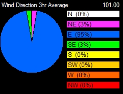
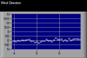
| Wind: | 6 mph from the E | |||||
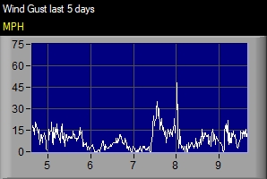
| Gust: | 8 mph | |||||
| Today's High Wind: | 30 mph at 12:25am | |||||
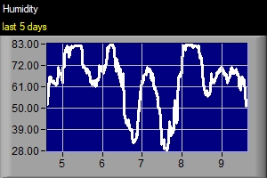
| Humidity: | 48% | |||||
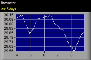
| Pressure: | 30.31 in (Steady) | |||||
| Pressure Rate: | -0.011 in/hr | |||||
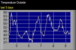
| Dew Point: | -8.7° | |||||
| Wind Chill: | -4.3° | |||||
| Heat Index (feels like): | 7.4° | |||||
| Comfort Level: | Extreme Cold | |||||
| Temperature Rate: | 2.02°/hr | |||||
| Today | Tonight | Wednesday | Wednesday Night | Thursday | Thursday Night | Friday |
| Chance Snow Showers | Slight Chance Snow Showers then Mostly Cloudy | Mostly Cloudy then Snow Showers Likely | Snow Showers | Snow Showers Likely | Chance Snow Showers | Slight Chance Snow Showers then Mostly Cloudy |
| 14° F | -4° F | 17° F | 10° F | 22° F | 1° F | 22° F |
| 0 to 5 mph | 0 mph | 0 to 5 mph | 5 to 10 mph | 5 to 10 mph | 5 to 10 mph | 5 mph |
| Friday Night | Saturday | Saturday Night | Sunday | Sunday Night | Washington's Birthday | Monday Night |
| Snow Showers | Snow Showers | Chance Snow Showers | Mostly Cloudy | Mostly Cloudy | Mostly Cloudy | Slight Chance Snow Showers |
| 15° F | 27° F | 3° F | 13° F | -5° F | 8° F | -5° F |
| 5 mph | 5 mph | 5 to 10 mph | 10 mph | 5 to 10 mph | 5 to 10 mph | 5 mph |


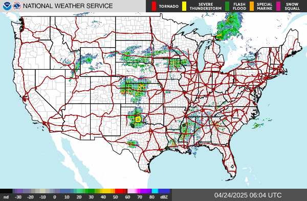
No Active Warnings at this time.
* WHAT...Heavy snow and light icing possible. Total snow accumulations between 4 and 7 inches and ice accumulations around a light glaze possible. * WHERE...A portion of southeast Michigan. * WHEN...From Wednesday afternoon through Thursday morning. * IMPACTS...Travel could be very difficult. The hazardous conditions could impact the Wednesday evening and Thursday morning commutes. * ADDITIONAL DETAILS...Uncertainty exists regarding the track of this system. A scenario for higher snowfall totals or more icing, with less snow, are both possible. A sharp gradient in snowfall is possible from north to south across each county.
-----------------------------------------------------------
* WHAT...Heavy snow possible. Total snow accumulations between 5 and 8 inches possible. * WHERE...A portion of southeast Michigan. * WHEN...From Wednesday afternoon through Thursday morning. * IMPACTS...Travel could be very difficult. The hazardous conditions could impact the Wednesday evening and Thursday morning commutes. * ADDITIONAL DETAILS...Uncertainty exists regarding the track of this system. A change in storm track may affect snowfall totals.
-----------------------------------------------------------
* WHAT...Snow expected. Total snow accumulations up to 6 inches. * WHERE...Western Chippewa County, especially along and west of the western shore of Whitefish Bay * WHEN...From 7 PM this evening to 7 AM EST Tuesday. * IMPACTS...Travel could be very difficult. The hazardous conditions could impact the Tuesday morning commute.
-----------------------------------------------------------
* WHAT...Heavy snow possible. Total snow accumulations of 6 or more inches possible. * WHERE...Portions of northern Indiana and southwest Michigan. * WHEN...From Wednesday afternoon through Thursday morning. * IMPACTS...Travel could be very difficult. The hazardous conditions could impact the Wednesday evening and Thursday morning commutes. * ADDITIONAL DETAILS...Snowfall rates of an inch per hour are possible, including during the Wednesday afternoon and evening commute.
-----------------------------------------------------------
* WHAT...Heavy mixed precipitation possible. Total snow accumulations between 5 and 7 inches and a light glaze of ice possible. * WHERE...Eaton, Ingham, Barry, and Kalamazoo Counties. * WHEN...From Wednesday afternoon through Thursday morning. * IMPACTS...Travel could be very difficult. The hazardous conditions could impact the Wednesday evening and Thursday morning commutes.
-----------------------------------------------------------
* WHAT...Heavy snow possible. Total snow accumulations between 5 and 8 inches possible. * WHERE...Portions of central, south central, southwest, and west central Michigan. * WHEN...From Wednesday afternoon through Thursday morning. * IMPACTS...Travel could be very difficult. The hazardous conditions could impact the Wednesday evening and Thursday morning commutes.
-----------------------------------------------------------
* WHAT...Lake effect snow. Additional snow accumulations up to two inches. Winds gusting as high as 35 mph. * WHERE...Northern Houghton County. * WHEN...Until 7 PM EST this evening. * IMPACTS...Plan on slippery road conditions. The hazardous conditions could impact the Monday evening commute. * ADDITIONAL DETAILS...Additional 2 to 4 inches of snow is expected tonight.
-----------------------------------------------------------
* WHAT...Lake effect snow expected. Total snow accumulations up to 5 inches, highest north of M-28. * WHERE...Luce County. * WHEN...From 7 PM this evening to 7 AM EST Tuesday. * IMPACTS...Plan on slippery road conditions. Patchy blowing snow could significantly reduce visibility. The hazardous conditions could impact the Tuesday morning commute.
-----------------------------------------------------------
Moderate lake effect snow bands are expected to move onshore later this morning with further intensification into tonight. Fluffy snow accumulations of 2 to 4 inches will be possible with localized higher amounts across eastern Luce County through tonight. Hazardous road conditions associated with this accumulating snow will be possible. Drivers are reminded to drive for the conditions and give yourself extra time to reach your destination. Always use your headlights and ensure there is extra space between yourself and other vehicles.
-----------------------------------------------------------